
Public Footpaths
The map below might not be the best quality image. It does, however, show the locations of all public rights of way in Budock Parish. The detailed route of each one is given lower down this page.
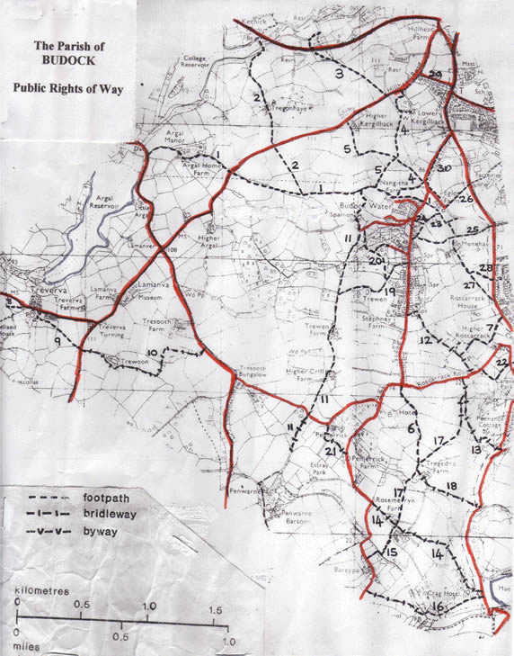
Map showing the public footpaths in the parish of Budock
The Footpaths
FP BW from Budock Church to road west of Argal Manor
Category: 3, Metres: 2304
FP from FP 1 to parish boundary west of Tregonhay
Category: 3, Metres: 1240
FP from Hillhead Road to southern boundary of A39 and from northern boundary of A39 to Waterworks Cottage
Category: 3, Metres: 680
FP from Hillhead Road to FP 1 with spur to Lower Kergilliack
Category: 3, Metres: 1134
FP from Higher Kergilliack to FP 1
Category: 3, Metres: 830
FP from Crill Corner to FP 17
Category: 3, Metres: 630
FP from BW/FP 12 near Roscarrack Mill to parish boundary
Category: 3, Metres: 500
FP from road west of Treverva to parish boundary
Category: 4, Metres: 123
FP from Treverva to road south of Little Lamanva
Category: 3, Metres: 410
BW from road south of Little Lamanva to road south of Tresooth
Category: 3, Metres: 1168
FP and BW from FP1 via Sparnon, Trewen, Crill to parish boundary
Category: 3, Metres: 2066
FP and BW from Budock Water Road to Roscarrack Road
Category: 2, Metres: 701
BW from Roscarrack Road to parish boundary (Pennance Mill)
Category: 2, Metres: 670
BW from south of The Home Hotel to parish boundary (Maenporth beach)
Category: 3, Metres: 1038
FP from Rosemerryn to parish boundary (Bareppa)
Category: 3, Metres: 275
FP from parish boundary (Maenporth boundary) to parish boundary
Category: 3, Metres: 438
FP & BW from BRl3 (north of Hard to Come By) to parish boundary
Category: 3, Metres: 1159
BW from FP17 (Tregedna) to parish boundary
Category: 3, Metres: 497
FP from Budock Water to BW/FP11 north of Trewen
Category: 3, Metres: 645
FP from FP19 to road south of Sparnon with spur to Budock Water
Category: 3, Metres: 631
BW from road west of Penjerrick to road north of The Home Hotel
Category: 3, Metres: 304
FP from Lower Crill to parish boundary
Category: 2, Metres: 409
FP from Budock Water to road south of St Budock Church
Category: 23, Metres: 450
FP from road north of Budock Water to FP23
Category: 2, Metres: 80
FP from FP23 ( Chapel Lane) to parish boundary (via Menehay House)
Category: 2, Metres: 570
FP from St Budock Church to parish boundary (Tregoniggie)
Category: 2, Metres: 201
FP from FP23 (St Budock Church) to parish boundary (via Menehay Farm)
Category: 2, Metres: 657
FP from FP27 to parish boundary
Category: 3, Metres: 150
FP from Hillhead Road to Union Hill (Old Union Road)
Category: 43, Metres: 104
FP from north of St Budock Church along side of perimeter of Bickland Industrial Estate to Falmouth FP 51
Category: 2, Metres: 525
Footpath Categories
Category 1 – National & Regional Routes
National Routes (e.g. South West Coast Path), Strategic Routes Promoted by Cornwall County (e.g. Saints Way, St Michael's Way).
Category 2 – Strategic Links
Links to Promoted and National Routes, Links between Communities, Routes known to be well used Local Paths.
Category 3 – Local Routes
Local Routes linking existing Highways, Local Circular Routes
Category 4 – Other Paths
Dead end Paths and little used Paths with Definitive Map, Anomalies and low value to the Network, Matters not covered in 1, 2 and 3 above.